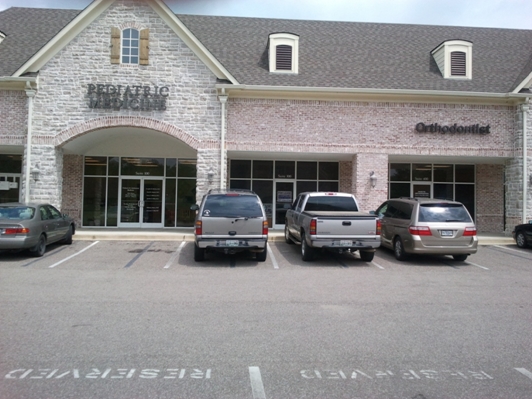
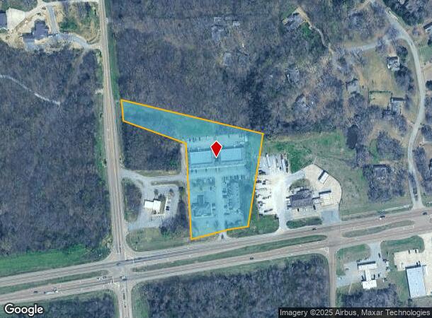
Property Record
3157 Highway 64, Eads, TN 38028
NEARBY LISTINGS FOR SALE OR LEASE
-
-
View all Eads listings for lease on LoopNet.com
Property Detail
3157 Highway 64
085-011.21
Part/Renaissance Coml Develop
Commercialnec
DISTRICT: 07, COUNTY AREA: P50
X
Fayette
47047C0280C
Tennessee
2024
4.05 AC
2024
Fayette County
060402
Memphis
7,705 SF
Memphis, TN-MS-AR
DEMOGRAPHICS near 3157 Highway 64
1 Mile
3 Mile
5 Mile
2024 Total Population
327
3,970
18,990
2029 Population
358
4,354
20,746
Pop Growth 2024-2029
+ 9.48%
+ 9.67%
+ 9.25%
Average Age
46
47
42
2024 Total Households
126
1,532
7,229
HH Growth 2024-2029
+ 9.52%
+ 9.40%
+ 9.28%
Median Household Inc
$92,646
$106,321
$89,517
Avg Household Size
2.50
2.50
2.60
2024 Avg HH Vehicles
3.00
3.00
2.00
Median Home Value
$379,999
$400,128
$274,012
Median Year Built
2000
2000
2003
Nearby Places
- Restaurants
- Banks
- Shops
- Fitness
- Groceries
PUBLIC TRANSPORTATION
AIRPORT
Memphis International
DRIVE
WALK
Distance
Memphis International
45 min
32.4 mi
Freight Ports
Port of Shreveport
DRIVE
WALK
Distance
Port of Shreveport
437 min
399.7 mi
SALE & LEASE HISTORY
LISTING DATE
SALE/LEASE

Sep 25, 2016
For Lease
Oct 10, 2017
For Lease
Jun 02, 2017
For Lease
Nearby Properties
Address
Land Use
TOTAL SIZE
Lot Size
Zoning
Address
Land Use
TOTAL SIZE
Lot Size
Zoning
60,234 SF
12.20 AC
Address
Land Use
TOTAL SIZE
Lot Size
Zoning
43,500 SF
15.06 AC
M2
Address
Land Use
TOTAL SIZE
Lot Size
Zoning
20,100 SF
2.13 AC
B2
Address
Land Use
TOTAL SIZE
Lot Size
Zoning
14,400 SF
4.05 AC
B2
Address
Land Use
TOTAL SIZE
Lot Size
Zoning
15,501 SF
2.06 AC
B2
Address
Land Use
TOTAL SIZE
Lot Size
Zoning
39,600 SF
2.03 AC
B2
Address
Land Use
TOTAL SIZE
Lot Size
Zoning
11,420 SF
3.09 AC
M2
Address
Land Use
TOTAL SIZE
Lot Size
Zoning
4,847 SF
2.59 AC
Address
Land Use
TOTAL SIZE
Lot Size
Zoning
13,525 SF
32.36 AC
Address
Land Use
TOTAL SIZE
Lot Size
Zoning
11,190 SF
30 AC
Address
Land Use
TOTAL SIZE
Lot Size
Zoning
4,015 SF
1.96 AC
B2
Address
Land Use
TOTAL SIZE
Lot Size
Zoning
25,800 SF
5 AC
M2
Address
Land Use
TOTAL SIZE
Lot Size
Zoning
6,600 SF
5.30 AC
Address
Land Use
TOTAL SIZE
Lot Size
Zoning
22,750 SF
5 AC
M2
Address
Land Use
TOTAL SIZE
Lot Size
Zoning
3,232 SF
4.16 AC
B2
Address
Land Use
TOTAL SIZE
Lot Size
Zoning
19,948 SF
3.02 AC
M2
Address
Land Use
TOTAL SIZE
Lot Size
Zoning
28,000 SF
2.42 AC
M2
Address
Land Use
TOTAL SIZE
Lot Size
Zoning
8,032 SF
2.30 AC
Address
Land Use
TOTAL SIZE
Lot Size
Zoning
15,224 SF
137.65 AC
Address
Land Use
TOTAL SIZE
Lot Size
Zoning
4,080 SF
4.44 AC
B2
Address
Land Use
TOTAL SIZE
Lot Size
Zoning
18,781 SF
1.15 AC
M2
Address
Land Use
TOTAL SIZE
Lot Size
Zoning
6,125 SF
2.58 AC
B2
Address
Land Use
TOTAL SIZE
Lot Size
Zoning
22,500 SF
1.73 AC
B2
Address
Land Use
TOTAL SIZE
Lot Size
Zoning
1,280 SF
3.05 AC
B2
Address
Land Use
TOTAL SIZE
Lot Size
Zoning
8,779 SF
21.15 AC
Address
Land Use
TOTAL SIZE
Lot Size
Zoning
10,440 SF
3.10 AC
M2
Address
Land Use
TOTAL SIZE
Lot Size
Zoning
5,622 SF
54.80 AC
Address
Land Use
TOTAL SIZE
Lot Size
Zoning
10,000 SF
2.85 AC
M2
Address
Land Use
TOTAL SIZE
Lot Size
Zoning
5,508 SF
71.40 AC
The World's #1 Commercial Real Estate Marketplace
Connect with us
© 2025 CoStar Group
The information above has been obtained from sources believed reliable. While we do not doubt its accuracy we have not verified it and make no guarantee, warranty or representation about it. It is your responsibility to independently confirm its accuracy and completeness. Any projections, opinions, assumptions, or estimates used are for example only and do not represent the current or future performance of the property. The value of this transaction to you depends on tax and other factors which should be evaluated by your tax, financial, and legal advisors. You and your advisors should conduct a careful, independent investigation of the property to determine to your satisfaction the suitability of the property for your needs.